| Iron County is a study in contrast from its arid western reaches of Escalante Desert and Great Basin ranges to the meadows and forests of the High Plateau on the east. The Markagunt Plateau is creased by the colorful formations of Cedar Breaks National Monument, a kind of miniature Bryce Canyon. Brian Head (11,307 feet), named for a profile resembling William Jennings Bryan, rises abruptly behind Iron County's major string of settlements and extracts a toll of precipitation from passing westerlies to feed the headwaters of the Sevier River.
Utah's Iron County was originally settled many centuries ago by native American tribes. They exploited the plants and animals of the basin and plateau environment in a complex seasonal pattern. Archaeological research in the area has identified at least four prehistoric cultures including the "Paleo-Indians" (10,000-6,000 BC), "Archaic Desert Culture" (7,000 BC - 500 AD), "Ansazi" and " Fremont" Indians (the local variant is called the Parowan Fremont) until about 1300 AD, and the Numic-speaking peoples (Southern Piutes) from 1300 AD until the time of white settlement. These natives lived in many small villages scattered primarily over a fertile valley between the high mountains on the east and the low lying Red Hills on the west. The Fremont people constructed granaries and pit houses dating from about A.D. 750 to 1250. Just to the south and west of the Red Hills was a large marshy area and lake now mostly dry.
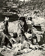
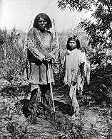
These prehistoric natives planted and harvested Indian corn in the valley soil. In the marsh they hunted small animals and water fowl, in the high mountains to the east, they hunted mule deer. From the desert to the west they harvested pine nuts. The following pictures of Paiute life were taken about 1874:
|

|
|
| Paiute Family
|
Paiute Wickiup
|
Paiute Elder and Boy
|
They found time to practice religious ritual and ponder celestial cycles. Among the most notable evidence of this study is the fascinating petroglyph (symbols and images inscribed on the surface of stone) site at Parowan Gap, about 12 miles northwest of Parowan. The petroglyphs and cairns at this site were probably created by the Parowan Fremont Indians and represent a comprehensive solar and lunar calendar that helped the pre-Colombian inhabitants track the solstices, equinoxes, planting and harvesting times, and moon cycles. They apparently tracked the seasons, solar solstices and equinoxes, lunar phases, cycles of Venus, even the best time to conceive children.
The first recorded white visit to the Parowan Gap petroglyph site was by members of an exploration party headed by Mormon Apostle Parley Pratt in the winter of 1849/50.
For more on the Parowan Gap Petroglyph site go to:
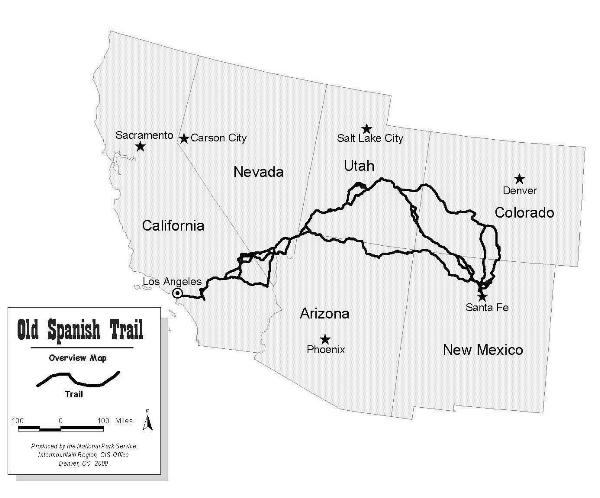
As they searched for a route to California in October 1776, a Spanish exploration party led by Franciscan priests Francisco Domingues and Velez de Escalante explored the area, traveling as far north as Utah Lake. Escalante reported finding rocks in the Cedar Valley with a very high iron content. Parts of their trail are now marked as the Old Spanish Trail.
Much of the Old Spanish trail was first established as trade and migration routes by Native Americans long before the arrival of Europeans. It was later heavily traveled in the 1830s and 1840s by hundreds of trappers, soldiers, and traders. Fur trapper Jedediah S. Smith was the first Anglo-American to visit present Iron County during his amazing journey of 1826. About a third of the 1,200-mile trail lies in Southern Utah with over 100 miles in Iron and Washington Counties. This trail in now marked in many areas by modern highways. The trail was a multithreaded trail akin to a braided stream. The trail split into two basic routes between Santa Fe, New Mexico and Los Angeles, California. It had north and south branches in the eastern end and other branches in the western, Mojave Desert, section. It saw New Mexican goods carried west for sale in Los Angeles. The reverse flow to Santa Fe included mules and horses that were purchased, or stolen, in southern California. Emigrants from New Mexico and points east also moved westward over the trail. Although most trail travel was by mule pack train, some portions of the trail eventually saw some wagon traffic. The first wagons to follow the trail were discharged members of the Mormon Battalion after the Mexican War, traveling from San Diego to Salt Lake City. For more information, check the Old Spanish Trail Assn or the Southern Utah Chapter of the Old Spanish Trail Assn websites.
|
|
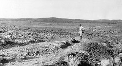
| Spanish Trail near Enterprise, Utah
|
Route of Spanish Trail
|
By the time time of the Spanish visit, the area was inhabited by semi-nomadic Piute Indians. These natives traveled and traded over an area ranging from Colorado to Mexico and California. Their descendants still live throughout southwestern Utah.
In 1847, Mormon refugees entered the Salt Lake Valley which was then Mexican territory. Under the leadership of Mormon prophet Brigham Young, many exploring parties were sent out to find other settlement sites throughout the mountain west.
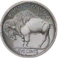
During the winter of 1849/50, a scouting party of approximately 50 men led by Mormon Apostle Parley P. Pratt was sent to the south. He camped at present-day Parowan, Utah and erected a flag pole which still stands today. He found water, game, and plenty of room to grow the crops necessary to sustain a settlement. He, like Escalante, also discovered the significant iron deposits. This ore (magnetite - Fe3O4) was later found to be as high as 60% iron! In 1850, Brigham Young organized the Iron Mission and called for volunteers to colonize the area and develop an iron industry.
On 15 December 1850 a settlement party of approximately 120 men with 30 women and 18 children led by Mormon Apostle George A. Smith left Fort Utah (modern day Provo). On 13 January 1851 they arrived at Center Creek and established Fort Louisa, later named Parowan (a Piute name meaning "evil water" because of the nearby Little Salt Lake). Within a week a local government was elected in what was, by then, United States territory.
On the surface, winter seems to be a bad time to travel uncharted territory to establish a new home in an unknown land. Nevertheless, the winter emigration was chosen to take advantage of the 1850 harvest in the Salt Lake Valley, make the move, and establish their settlement before spring planting time.
Fort Louisa was 56 rods (308 yards) square with 94 lots. Soon homes were built within the fort and the construction of a church was started. The town square of present day Parowan conforms to the site of the old fort. The church still stands in the very center of the town square and many of the era's adobe structures are still in use.
A site near Coal Creek was selected in November 1851 for the Iron Works because it was conveniently located between the iron deposits to the west, coal deposits and timber to the east, and water. Originally called Little Muddy, then Coal Creek, Cedar City was named for the cedar (actually juniper) trees in the area. When the first Cedar City settlers arrived from Parowan on 11 November 1851, they lifted their wagon boxes off the running gear to use as temporary shelters in a cove on the north side of a hill on the north end of present day Cedar City. By the end of November, the settlers had establish a site for a fort nearby (Old Fort Plat) and began construction of homes, the rear walls comprising the fort walls. The fort would be moved twice before arriving at the final site for the establishment of Cedar City. The first fort site was abandoned because Mormon leader judged the new fort to be too close to a hill and therefore vulnerable to Indian attack from above. The second site for Cedar Fort (also called Plat A) was surveyed by William H. Dame in 1852-3. The eight-foot adobe wall was complete by January 1854. Present day I-15 bisects the site of this fort and the western boundary was approximately where today's Airport Road is. Due to Coal Creek flooding, this fort was abandoned for a new site (Plat B) near today's park at 200 North and Main streets.
Several pioneer log homes remain in the county as well as some English two-bay log barns now very rare in the state.
Ten months after initial site selection, the new colony completed a small blast furnace in Cedar City and began to operate the iron foundry. The furnace was charged with a mix of ore, coked coal, and limestone. The first iron was produced on the morning of 30 September 1852. It was the first iron to be manufactured west of Missouri, but the quality was poor due to the high sulfur content of the coal.
The settlements were called the "Iron Mission" because settlers were called by their church to serve a mission to produce iron for the growing Mormon presence in the Intermountain west. Like the missionaries called in ancient times by Christ, these settlers received no financial support on their mission. They were not paid for their mission labors. Instead, they had to support their mission through farming and subsistence hunting. The mission was later converted to a cooperative owned by many of the settlers and other investors -- the Deseret Iron Company.
Many attempts at iron production were made, some with greater success than others. The "ironmen" were challenged by finding the right mix with which to charge the furnace, inadequate materials from which to build the furnace, furnace design, equipment breakdowns, floods, Indian hostilities, manpower shortages, insufficient financing, and prioritizing iron production vs survival. The community was further tested by profound poverty -- many settlers wore rags and some even had no shoes.
After the mission was converted to the Deseret Iron Company, a company store was established. A skill-based pay scale was devised. Because of the scarcity of cash, few, if any, workers were paid in cash. Instead, pay was posted to an account at the company store. Workers drew their pay in the form of goods and services on their company store account. Likewise, suppliers were rarely paid in cash, but through the company store account books.
The best recorded iron production run was 9-22 April 1855 when the Deseret Iron Company produced nearly 9,000 pounds of good iron from the "Noble Furnace." The run apparently was stopped because they had run out of stockpiled fuel. Several subsequent production attempts were made, but none equaled the April 1855 run. The foundry closed in 1858 deeply in debt and having produced only about 25 tons of pig iron.
The iron works failed to live up to dreams and expectations. It never made a profit for various reasons the settlers could never control or even understand: the flow of Coal Creek was too unpredictable to provide consistent furnace operation; they did not have good materials for lining their furnaces; the local coal contained too much sulfur; they had insufficient capital and inadequate scientific knowledge.
While in production, the foundry used "Iron Mission" iron to make a wide range of items including stoves, bells, tools, machine parts, farm implements, and much needed nails. This production proved very valuable to the Mormon settlements, since pre-railroad (1869) freight costs from St. Louis, Missouri ran about $200 per ton.
Unlike many small mining towns of that era, Cedar City continued to grow and prosper. By 1870, Cedar City numbered 2,000 inhabitants. Residents turned to farming for economic well being. Mining continued to play a small part in the economy through WWII to the 1980’s. Other smelting furnaces and foundries were established over the years to exploit the local iron deposits, but none remain in operation. A substantial amount of ore was shipped to smelters in Utah county, California, and Colorado with the most recent shipment in 1994. Although a great deal of iron ore remains, it is not currently mined because it is more expensive than recycled iron and imported steel. Reserves of over 200 million tons of high grade ore remain for development when prices are better.
The Iron Missionaries discovered coal very soon after their arrival in the area. In addition to its exploitation for the iron industry, local coal was mined for heating homes, churches, and other buildings as well as for electricity generation. Local coal mining ceased in 1965 when cheaper electricity became available from the hydroelectric generators of the new Glen Canyon Dam and homes and businesses converted to cleaner, cheaper natural gas for heating. It is estimated that the area has over 230 million tons of reasonably accessible coal reserves.
In 1897 the people of Cedar City learned that the Utah Legislature had authorized a school for higher learning in Southern Utah. Until then, local education opportunities were limited to 6th grade. This new "Branch Normal School" would offer what we consider to be education at the high school level. The community labored to construct the Ward Hall. However, after being in session only two months the Attorney General stated that the school had to have its own building on land deeded to the state, and if a building was not erected by the following September, funding for the school would be forfeited. By that point winter had set in and building materials in Cedar City were nonexistent. But Cedar City residents argued “Nobody was going to take their school away from them.”
For four days men of the town waded through snow that was often shoulder deep, pushing their way up the mountain to the lumber mills in the canyons. They slept in holes scraped out of the snow. After reaching the sawmills the men found that they had to turn back. The wagons that could not make it were abandoned. Tired to the bone, the party felt they couldn’t go any further. It was at this phase of their march that an old sorrel horse proved invaluable. Placed out at the front of the party, the horse would walk steadily into the drifts, pushing against the snow, throwing himself into the drifts again and again until they gave way. Then he would pause for a rest, sitting on his haunches the way a dog would. Then onward he would push. “Old Sorrel” was credited with being the savior of the expedition. In 1898 the building was complete, and Cedar City had its school.
In 1913 the college was renamed Branch Agricultural College (BAC) and became a branch of Utah State Agricultural College of Logan. At this point it grew into a combined high school and junior college. By the fall of 1941, all high school studies had been moved to the new Cedar High School on an adjacent campus. During World War II, the college campus was used to train aviation cadets for the war effort. In 1949 a department of elementary education was added and the first bachelor's degrees were awarded in 1950. In May 1953, the college was renamed College of Southern Utah. On 11 Mar 1965, the Governor of Utah signed a bill making the College of Southern Utah an independent state college. In 1968, the Utah State Legislature transformed it into a 4-year college of liberal arts and sciences with elementary and secondary teacher education programs. Its name was changed to Southern Utah State College in 1969. On 1 January 1991 it attained university status with its present name -- Southern Utah University. Presently the university is the home of the Utah Shakespearean Festival and The Utah Summer Games.
The railroad came to Iron County in 1899, but bypassed all major communities. The nearest station to Cedar City was at Lund. The Lund Highway connected the two communities so rail borne products could be trucked to local consumers and local agricultural products could be shipped to outside purchasers. After many years of rumors and speculation, the Union Pacific Railroad Company finally added a rail spur to Cedar City in 1923. This development contributed greatly to Cedar City’s growth in mining, providing an outlet for the production of the iron mines. The railroad also contributed greatly to the growth of agriculture and tourism. The railroad helped expose Utah’s National Parks to the world of tourism and Cedar City was dubbed “the gateway to the parks.” The railroad still comes through Cedar City and transports products in and out of the community. However, the depot was closed in 1959.
Needing a larger meeting house, the settlers built the Cedar City Tabernacle on the northwest corner of Main Street and Center Street. Construction began in 1883. The building was completed in 1888. It was a stately three-story building with arched doors and windows. The first recorded meeting in the new building was held in March 1887. The tabernacle was razed in 1932 to make way for a new post office and federal building.
The removal of the tabernacle left the LDS First Ward without a meeting place. Of the many old buildings still standing around town, and probably the most familiar, is Rock Church built to replace the old tabernacle. It was built from 1930 to 1934 with local stone, pine and juniper, iron, and volunteer labor. It was first used in 1932 and is still in full use today.
The Old Hospital built in 1922 with total local support was another such building that represents the community feeling of Cedar City. All of the land and equipment for this building were donated. When the new hospital was built in 1964 the Old Hospital was donated to the College for dorms and classrooms. Later it was acquired and renovated by the Dixie Leavitt Group for its offices.
The Escalante Desert has changed its name to Escalante Valley, reflecting the rich irrigation agriculture of hay, small grains, and potatoes. The west end of the county also has some historic and current precious metal mining.
Iron County has a more balanced and broadly based economy than most of rural Utah. Located on Interstate 15, Cedar City is 500 miles from Los Angeles, 180 miles from Las Vegas, and 260 miles from Salt lake, and about midway between Los Angeles and Denver via I-70. Its location and size have made it a regional trade center and supplier of services. The concessionaire for nearby national parks (an edge of Zion is in the county) has offices here, as do regional offices of the Bureau of Land Management, Dixie National Forest, and Utah Wildlife Resources. A railroad spur and regional airline still serve the city. A rocket motor fuel plant is under construction. A very good four-year liberal arts college, Southern Utah State, combined with a peerless Shakespearean Festival in the summer make Cedar City an attractive stop for some of the more than one million people who annually pass through.
Return to top
|
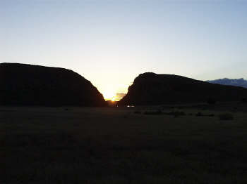
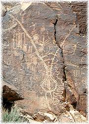 To find the Parowan Gap petroglyph site, continue north from Enoch on U130. At about 12.5 miles north of Cedar City, turn right (east) to Parowan Gap (about 2.5 miles from the turn). These inscriptions were probably inscribed by different cultures at different times during at least a 1,000 year period. Please do not touch the inscriptions nor even climb the hill for a better look.
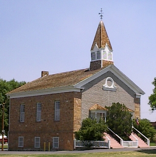 Parowan's "Rock Church" is the oldest building in the county. It is located in the center of Parowan and in the center of the old "